Showing posts with label Alaska. Show all posts

Saturday, August 30, 2014

Ring Of Ice


Prominence of earthquakes in North America and around Greenland has prompted a team of researchers led by Arctic-news blog editor Sam Carana to coin the phrase “Ring Of Ice” to describe what they see happening in the Arctic.

“Melting of ice in north Canada and on Greenland is causing pressure changes, resulting in seismic activity”, explains Sam Carana.

Heavy seismic activity is ocurring along the faultlines that constitute the border of the North American Plate, similar to the the heavy activity along the Ring Of Fire around the Pacific Ocean.

Seismic activity roughly follows the borders of the North American Plate, which includes Greenland. However, where the major fault bends away to the west following the Aleutian Islands, seismic activity continues north through Alaska along a line that extends over the North Pole toward Svalbard.

This northward path through Alaska is illustrated by the earthquakes on the image below.


“Earthquakes are prominent along the entire border of the North American Plate”, Sam Carana adds, “but they increasingly appear to be taking this shortcut through Alaska and the underlying cause of this is melting of ice in north Canada and on Greenland”.

“This Ring Of Ice spells danger, just like the name Ring Of Fire indicates danger”, Sam Carana concludes. “The name Ring Of Fire warns about possible volcanoes, earthquakes, landslides and tsunamis. The Ring Of Ice seems even more dangerous, since seismic activity could destabilize methane hydrates contained in sediments under the Arctic Ocean, and could trigger huge methane eruptions. The fault line running from Greenland to Siberia is the most dangerous area on Earth in that respect”.

From the earlier post High Methane Levels over Laptev Sea


Tuesday, February 4, 2014

As continental U.S. freezes, Alaska gets record high temperatures

While much of the continental United States endured several cold snaps in January 2014, record-breaking warmth gripped Alaska. Spring-like conditions set rivers rising and avalanches tumbling. NASA Eartobservatory illustrates the above words with the two images below.


Above map depicts land surface temperature anomalies in Alaska for January 23–30, 2014. Based on data from the Moderate Resolution Imaging Spectroradiometer (MODIS) on NASA’s Terra satellite, the map shows how 2014 temperatures compared to the 2001–2010 average for the same week. Areas with warmer than average temperatures are shown in red; near-normal temperatures are white; and areas that were cooler than the base period are blue. Gray indicates oceans or areas where clouds blocked the satellite from collecting usable data.

A persistent ridge of high pressure off the Pacific Coast fueled the warm spell, shunting warm air and rainstorms to Alaska instead of California, where they normally end up. The last half of January was one of the warmest winter periods in Alaska’s history, with temperatures as much as 40°F (22°C) above normal on some days in the central and western portions of the state, according to Weather Underground’s Christopher Bart. The all-time warmest January temperature ever observed in Alaska was tied on January 27 when the temperature peaked at 62°F (16.7°C) at Port Alsworth. Numerous other locations—including Nome, Denali Park Headquarters, Palmer, Homer, Alyseka, Seward, Talkeetna, and Kotzebue—all set January records.

The combination of heat and rain has caused Alaska’s rivers to swell and brighten with sediment, creating satellite views reminiscent of spring and summer runoff. On January 25, 2014, the Aqua satellite collected this image of sediment flowing into the Gulf of Alaska from numerous rivers along the state’s southeastern coast.

All of the heat, moisture, and melting snow has elevated the risk of avalanches. A series of extremely large avalanches in late January sent snow and debris crashing onto the Richardson Highway, blocking the road and cutting the port town of Valdez off from highway access. The avalanches dumped a mound of snow 100 feet (30 meters) tall and up to 1,500 feet (460 meters) long on the highway.


Below are two videos with forecasts for the period from February 4, 2014, to February 11, 2014. The top video shows temperature forecasts and the bottom video shows temperature anomaly forecasts.


Warmer temperatures over the Arctic have resulted in a slowdown of sea ice are growth, as illustrated by the image below (yellow line top left shows 2014 values).


Related posts

- Forecast: America to be hit by temperatures as low as minus 40 degrees
http://arctic-news.blogspot.com/2014/01/forecast-america-to-be-hit-by-temperatures-as-low-as-minus-40-degrees.html

- The Biggest Story of 2013
http://arctic-news.blogspot.com/2013/12/the-biggest-story-of-2013.html

- Polar jet stream appears hugely deformed
http://arctic-news.blogspot.com/2012/12/polar-jet-stream-appears-hugely-deformed.html


Thursday, June 27, 2013

The Threat of Wildfires in the North

NASA/NOAA image based on Suomi NPP satellite data from April 2012 to April 2013, with grid added
A new map has been issued by NOAA/NASA. The map shows that most vegetation grows in two bands, i.e. the Tropical Band (between latitudes 15°N and 15°S) and the Northern Band in between 45°N and 75°N, i.e. in North America, Europe and Siberia. On above image, the map is roughly overlayed with a grid to indicate latitude and longitude co-ordinates.


Vegetation in the Northern Band extends beyond the Arctic Circle (latitude 66° 33′ 44″ or 66.5622°, in blue on above image from Arcticsystem.no) into the Arctic, covering sparsely-populated areas such in Siberia, Alaska and the northern parts of Canada and Scandinavia. Further into the Arctic, there are huge areas with bush and shrubland that have taken thousands of years to develop, and once burnt, it can take a long time for vegetation to return, due to the short growing season and harsh conditions in the Arctic.


Above map with soil carbon content further shows that the top 100 cm of soil in the northern circumpolar region furthermore contains huge amounts of carbon.

May 16 2013 Drought 90 days Arctic
Global warming increases the risk of wildfires. This is especially applicable to the Arctic, where temperatures have been rising faster than anywhere else on Earth. Anomalies can be very high in specific cases, as illustrated by the temperature map below. High temperatures and drought combine to increase the threat of wildfires (see above image showing drought severity).

June 25, 2013 from Wunderground.com - Moscow broke its more than 100-year-old record for the hottest June 27
Zyryanka, Siberia, recently recorded a high of 37.4°C (99.3°F), against normal high temperatures of 20°C to 21°C for this time of year. Heat wave conditions were also recorded in Alaska recently, with temperatures as high as 96°F (36°C).

On June 19, 2013, NASA captured this image of smoke from wildfires burning in western Alaska. The smoke was moving west over Norton Sound. (The center of the image is roughly 163° West and 62° North.) Red outlines indicate hot spots with unusually warm surface temperatures associated with fire. NASA image by Jeff Schmaltz, LANCE/EOSDIS Rapid Response. Caption by Adam Voiland. - also see this post with NASA satellite image of Alaska.
Siberian wildfires June 21, from RobertScribbler 
from methanetracker.org

Wildfires raged in Russia in 2010. Flames ravaged 1.25 million hectares (4,826 mi²) of land including 2,092 hectares of peat moor.

Damage from the fires is estimated to be $15 billion, in a report in the Guardian.

Cost of fire-fighting efforts and agricultural losses alone are estimated at over $2bn, reports Munich Re, adding that Moscow's inhabitants suffered under a dense cloud of smoke which enveloped the city. In addition to toxic gases, it also contained considerable amounts of particulate matter. Mortality increased significantly: the number of deaths in July and August was 56,000 higher than in the same months in 2009. 


[From: Abrupt Local Warming, May 16, 2012]

Wildfires in the North threaten to cause large emissions of greenhouse gases and soot, which can settle on snow and ice in the Arctic and the Himalayan Plateau, with the resulting albedo changes causing a lot more sunlight to be absorbed, instead of reflected as was the case earlier. This in turn adds to the problem. Additionally, rising temperatures in the Arctic threaten to cause release of huge amounts of methane from sediments below the Arctic Ocean. This situation threatens to escalate into runway global warming in a matter of years, as illustrated by the image below.

How much will temperatures rise?
In conclusion, the risk is unacceptable and calls for a comprehensive and effective action plan that executes multiple lines of action in parallel, such as the 3-part Climate Action Plan below. Part 1 calls for a sustainable economy, i.e. dramatic reductions of pollutants on land, in oceans and in the atmosphere. Part 2 calls for heat management. Part 3 calls for methane management and further measures.


The Climate Action Plan set out in above diagram can be initiated immediately in any country, without the need for an international agreement to be reached first. This can avoid delays associated with complicated negotiations and on-going verification of implementation and progress in other nations.

In nations with both federal and state governments, such as the United States of America, the Climate Action Plan could be implemented as follows:
  • The President directs federal departments and agencies to reduce their emissions for each type of pollutant annually by a set percentage, say, CO2 and CH4 by 10%, and HFCs, N2O and soot by higher percentages.
  • The President demands states to each make the same cuts. 
  • The President directs the federal Environmental Protection Agency (EPA) to monitor implementation of states and to act step in where a state looks set to fail to miss one or more targets, by imposing (federal) fees on applicable polluting products sold in the respective state, with revenues used for federal benefits.
Such federal benefits could include building interstate High-Speed Rail tracks, adaptation and conservation measures, management of national parks, R&D into batteries, ways to vegetate deserts and other land use measurements, all at the discretion of the EPA. The fees can be roughly calculated as the average of fees that other states impose in successful efforts to meet their targets.

This way, the decision how to reduce targets is largely delegated to state level, while states can similarly delegate decisions to local communities. While feebates, preferably implemented locally, are recommended as the most effective way to reach targets, each state and even each local community can largely decide how to implement things, provided that each of the targets are reached.

Similar targets could be adopted elsewhere in the world, and each nation could similarly delegate responsibilities to local communities. Additionally, it makes sense to agree internationally to impose extra fees on international commercial aviation, with revenues used to develop ways to cool the Arctic.

- Climate Plan

Thursday, September 13, 2012

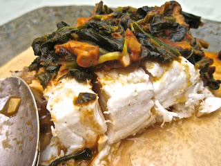
Alaskan Halibut in a Roasted Tomato-Spinach-Shiitake Mushroom Sauté

When the Deadliest Catch first aired, I watched with morbid curiosity as the crews manhandled heavy metal cages. Those cages sometimes swung wildly in the air, smashing against the ship's bulkhead, threatening to hospitalize crew members.

Many times, risking life and limb did not have the hoped for payoff when the cages contained the ocean's odds and ends rather than the prized catch of Alaskan king crab.

When luck was with them, a cage would be filled with crabs, their pointed, armored legs poking out at any hand that risked a close encounter.

After that, when I ordered a crab cocktail I had newfound respect for my food. The crab meat might be delicate and sweet, but the effort it took to snatch it from the icy, turbulent ocean was marked by sweat, fear and danger.

On so many levels, when I am cooking or about to eat, I am happy to be ignorant of the difficult work it takes to get the food from ocean or farm to my table.

Recently, the Alaska Seafood Marketing Institute made it easy for me. They offered to send a box of Alaska seafood for me to prepare and write about.

Certainly I had bought, cooked and eaten Alaskan seafood before because it is available from local purveyors big (Ralphs and Gelson's) and small (Malibu Seafood).
From the extensive seafood available in Alaskan waters, I was offered king crab (how could I refuse!), halibut, cod, salmon and scallops. When the samples arrived, I happily opened the super-sized box to find the two pound vacuum packed packages of seafood perfectly chilled by dry ice and freezer packs.

I began my Alaskan adventure with the halibut.
Halibut with Roasted Tomato Sauce, Spinach and Shiitake Mushrooms

A thick filet can be cut into smaller pieces or prepared whole, which in this instance, meant a piece just under two pounds in weight. I liked the idea of cooking the filet whole and then slicing manageable pieces for serving.
A key ingredient is the roasted tomato sauce. You can certainly buy canned sauce, but homemade roasted tomato sauce is wonderfully easy to make, tastes much better than any commercial version and can be prepared and refrigerated several days in advance or frozen weeks or even months before using.

Serves 4

Ingredients

2 pounds halibut filet
1 bunch spinach, roots removed, washed to remove grit
4 large ripe tomatoes, washed, stems removed
2 garlic cloves, washed, ends and skins removed, finely chopped
6 shallots or 1 medium yellow onion, washed, ends trimmed and skins removed, roughly chopped
1/4 pound or 6-8 shiitake mushrooms, stems trimmed, washed and pat dried, roughly chopped or thin sliced
1 tablespoon sweet butter
3-4 tablespoons olive oil
Sea salt and pepper to taste

Directions

Preheat the oven to 400 F degrees. Place the tomatoes on a baking tray lined with a nonstick Silpat sheet, parchment paper or aluminum foil.  Drizzle with 1 tablespoon olive oil. Season with sea salt and pepper. Bake 1 hour. Remove and let cool.
The liquid in the bottom of the baking tray is a combination of seasoned olive oil and a clear liquid given off by tomatoes when they cook. Set up a food mill or a fine mesh stainer over a non-reactive bowl.  Pour the olive oil-tomato liquid into the food mill/strainer and add the cooked tomatoes.

Press the tomatoes through the mill/strainer, using a rubber spatula to collect all of the pulp on the bottom side of the mill/strainer.  Discard the seeds and skin or use with other ingredients to make a delicious vegetable stock.

Place the roasted tomato sauce aside in a sealed container. If not used immediately, refrigerate up to several days or freeze.

Defrost, wash and pat dry the halibut and set aside.

Heat the remaining olive oil in a large frying pan. Season with sea salt and pepper.

Many people discard spinach stems. I prefer to use them. Finely chop the stems and sauté until lightly browned. Add the shiitake mushrooms, onions and garlic and sauté until softened. Roughly chop the spinach leaves and add to the frying pan.

Once the leaves have begun to wilt, add the roasted tomato sauce (between 1 and 1 1/2 cups) and sweet butter. Simmer for ten minutes. Taste and adjust with sea salt and pepper as needed.

The halibut filet can be grilled on a barbecue or sautéed in a frying pan with similar results.  If you are using a barbecue, to prevent the fish from sticking, be certain to apply oil to the grill. Pour 1 tablespoon of oil on a paper towel and liberally rub across the grill.

If you are using a frying pan, use 2 tablespoons of olive oil and heat on a medium flame.

Using a large metal spatula to carefully lift the fish without leaving any of the flesh behind, lightly brown the filet on both sides.

Place the halibut on a cutting board and carefully slice the filet into large pieces.  Place on a serving platter and top with the heated vegetable sauté.

Serve with freshly cooked pasta or rice or with fresh baked French bread.

Variations

Along with the vegetables, sauté one piece of bacon, finely chopped, until lightly browned.

For a Spanish style flavor, season the vegetable sauté with 1/2 teaspoon paprika.

For heat, season the vegetable sauté with 1/4 teaspoon cayenne.


Sunday, September 9, 2012

High September 2012 methane levels

An earlier post reported average hourly methane measurements as high as 2500 ppb recorded at Barrow, Alaska. Sadly, hardly any further in situ measurements have been publicly released from Barrow since, as illustrated by the image below.


Flask measurements continue to be available and the five most recent measurements show levels well over 2000 ppb.


The image below shows methane levels over a period of three years, from August 1, 2008, to August 1, 2011.


The image below shows methane levels over a period of a more recent year, from August 1, 2011, to August 1, 2012. There is a marked increase of methane at higher latitudes, compared to the earlier three years.


The image below shows methane levels in August 2012, with high levels showing up at many places. 


The image below shows the most recent methane level measurements available, from September 1, 2012, to September 7, 2012. High levels of methane show up at even more places, such as in the Arctic to the north of North America.

Around this time of year, there will typically be a lot of methane at many locations on the Northern Hemisphere. The image below allows a comparison of the 2012 period with the same period last year. In early September 2011, there was not quite as much methane as there now is north of Alaska, in Greenland and along the Siberian coast. There was a lot of methane in China last year in this period in 2011, though, and the situation appears to have improved somewhat this year.

To compare things further, an image is added below showing methane levels during the same period in 2010.

Below are added images produced by Dr. Leonid Yurganov from IASA data. Note that the scales are slightly different. The images confirm the presence of high levels of methane in the Arctic Ocean north of Siberia. Further below a combination picture showing the significant rise of methane levels in that area between October 2008 and October 2011.


[click to enlarge]

The images highlight a number of concerns:
  1. Methane levels are rising over the years; 
  2. Methane levels are particularly high in the Arctic;  
  3. Very high levels of methane are recorded in the Arctic in the months September and October, the very period when Arctic sea ice is at its lowest; 
  4. Incidental measurements, such as at Barrow, add to concerns that levels can rise abruptly with significant amounts. 
Methane is more than 100 times as potent as a greenhouse gas as carbon dioxide over 20 years, and even more potent over shorter periods. This makes methane a very powerful warming factor in the Arctic. While the Arctic is already warming more than three times as fast as the rest of the world, the sea ice still acts as a buffer to prevent even more acceleration of warming in the Arctic, but this situation will deteriorate dramatically as the sea ice disappears, as Professor Peter Wadhams recently described.

The big danger is that ferocious warming in the Arctic will trigger methane releases from hydrates and from free gas in sediments, which will further accelerate warming in the Arctic and further trigger methane releases, in a vicious circle set to spiral into runaway global warming unless action is taken to reduce the danger.